COUNCIL MISQUOTED THE HILL DISTANCE TO CITY

Park & Ride to Outer CBD
Click to enlarge
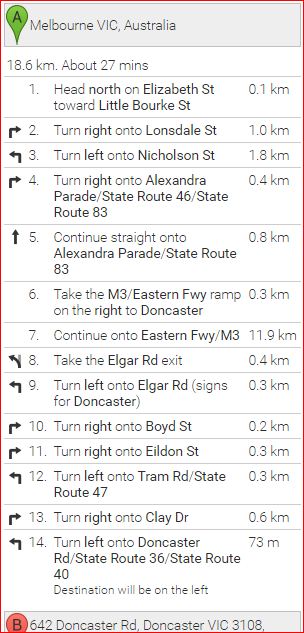
Doncaster Hill to GPO
Click to enlarge
But the website of the “Nest at the Hill”, a major apartment development opposite Westfield shopping centre, at 642 Doncaster Road, Doncaster Hill, have made no bones about accurately stating that the complex is a 18.9 km driving distance from the Melbourne CBD (actually the GPO) and 2.4 km from Park and Ride, on western border of the Manningham Municipality.
John S wrote; “Manningham Council, usually a stickler for accuracy and impartiality, appear to want to create an impression that
Manningham is much closer to the City by referring to the straight line (by air) distance from Western boundary of Manningham to the outer edge (1 Nicholson Street) of the Melbourne CBD”

Nest Sales brochure
Click to enlarge

GPO to Council Offices Click to enlarge
“The 10 km distance they refer to on the Manningham website is understated.The 10 km arc in the Melways directory runs through Bulleen near the eastern freeway which is 13.69 kilometers driving distance to the Melbourne GPO from the border of Manningham however there is no high density development in that area and would not be much good for residents from the Doncaster High Rise apartments five kilometers away who would travel past that point on their way to the city. It would be very confusing for many people because distances are often measured to or from the Melbourne GPO. In other material published on their website council are saying that Doncaster Hill is a straight line distance of 12 km from the Melbourne Central Business District but it is actually 15 km. The road distance from the Melbourne GPO to Manningham Council offices is 19 km via the eastern freeway”.
“Council may not be subject to the law relating to misrepresentation, as in private enterprise, but when dealing with overseas buyers not familiar with the area, it is all the more reason to avoid giving incorrect information on its website that could induce a party to make a contract, which might rely on what council have represented and suffer loss as a result, where a party in the private arena would normally claim damages”
7 Comments
If you want to quote a distance it is best that it be expressed as a road distance not on a straight line because it can vary to blazes. “Nest at the Hill” are selling to overseas developers and don’t want and problems that might blow an apartment sale especially with the predicted downturn in prices predicted in 2017. Which is why they are not fooling around by quoting a distance by air.
Make all distances by the shortest road route and from the Melbourne GPO as standard. That would remove a lot of the confusion.
According to the Melways directory Westfield Doncaster Hill is just under 15 km from the Melbourne GPO (as the crow flies) but the Doncaster Hill website says it is approximately 12 km which is obviously wrong. According to your road distance calculator you have posted it at 16.6 km from the GPO. In past years agents would often quote both the road distance and travel times. With 1000 apartments on the market at once around around Doncaster Hill it might be better to represent the road distance from Doncaster Hill GPO to Melbourne GPO that way there could be no argument.
If the railway station had been built on Doncaster Hill people would be more inclined to leave their cars at home and the distance from the city would not be so important when your travelling in the comfort of a train. Instead of standing in traffic gridlock during peak periods on the eastern freeway. Being connected to the railway network would also allow travel to other stations throughout Melbourne.
Only the areas of Geelong, Mornington and Melton are ahead of Manningham as the highest user of cars. The reason for that is not only the distance Manningham is from the city but its lack of connection to fixed rail transport. Recent studies show that for every kilometer traveled on the eastern freeway in morning peak a motorist will spend more than a minute sitting in gridlock.It takes nearly 11 minutes longer for a 20 km trip than it did back in 2004.
The country is run by the faceless, unaccountable and unelected bureaucrats not the Councils or the politicians who are their puppets. Why would you select such an isolated area without proper public transport and infrastructure to be a major activity centre? It has only gone ahead because of the flood of overseas money.
Doncaster Hill Strategy was adopted by the Manningham Council in October 2002. Council set out a vision for the area within a 20 year time frame where Doncaster Hill was to evolve into a Sustainable Urban Village accommodating some 8,300 residents, with 10,000 additional jobs. That looks hardly likely now given that already 67% of the work force have to travel outside of Doncaster to there place of employment. ….Which is one of the reasons we have such high car use in Doncaster.