PEDESTRIANS A MEASURE OF IDEAL URBAN SPACES
“Artists, philosophers, urban planners and architects have been dreaming, writing about and drawing ‘ideal cities’ for hundreds of years…In most of these visions the pedestrian is the measure of ideal urban spaces.” From European Cooperation in Science and Technology (Methorst 2010, p.34)
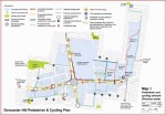
Tracy D. Writes.. “Council have not provided the proper facilities for walking and cycling on Doncaster Hill which is a fundamental requirement for an Activity Centre. The proposed walking path, shown in pink in plan two, was previously a widened footpath, shown in blue in plan one. It was to be shared with cyclists but has been “quietly” scrapped because it had failed to meet safety standards. Why it is now designated as a useless walking route on existing footpaths, is puzzling. I suppose it might be useful for those not familiar with the area who might want to walk around the Doncaster Hill perimeter or a more cynical explanation might be that it was hoped no one would
notice the change and give the false impression that the shared path had been retained, especially for those who might not refer to the legend, thereby minimise the embarrassment of having spent so much of ratepayers resources on engaging engineers, and consultants and the glossy publications on its promotion. Apart from the original shared path through the sports ground towards Ruffey Lake and a shared path from the Civic Centre to Westfield Shopping Centre there is very limited opportunity for cycling unless riders want to share bus lanes”
There was strong opposition to the shared paths plan because of pedestrian safety, when it was released back in 2003. The street gradients throughout the Doncaster Hill area were well in excess of the 3% maximum slope recommended by the State Authority who were never consulted. It took more than 7 years of petitions and letters before it was finally cancelled.
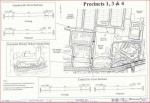
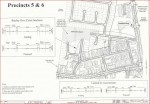
Below are detailed drawings showing the shared Pedestrian & Cycling route and the streets to be narrowed to make way for wider footpaths. For example Short Street in Precinct 2 would have been reduced to 5.86 metres!
According to material I have read, road environments in Activity Centres must not only accommodate all modes of traffic but also provide a pleasant, comfortable and safe environment for pedestrians and cyclists. Unfortunately this is not happening on Tram Road, where, apart from the pedestrian lights at the Doncaster Road intersection, there are no opportunities for pedestrians to safely cross except for the subway at the eastern freeway more than a kilometre away from Doncaster Road. While there are plenty of bus stops on either side of the road, it is extremely dangerous to cross and access them because of the high volumes of traffic which is also causing cyclists to ride on the footpath because there are no bicycle lanes. It is interesting to note that Tram Road is supposed to be part of the proposed metropolitan cycling route. Vic Roads bicycle network in Manningham.
According to Victoriawalks….Walking should be favoured as the realistic and preferred form of transport for short trips. Currently, in many road situations the pedestrian who is using less of the road, less of the planet’s resources, less imported oil that depletes our balance of trade, that emits less noise and pollution, is not rewarded. Preference goes to single occupants in cars, whose unsustainable choices are favoured when pedestrians and cars meet. The constant provision of more car parking spaces is a classic example of how poor strategy simply favours one choice over another. We need facilities and urban design that support and promote the pedestrian over other transport modes, in those locations where walking is the most cost effective and efficient form of moving people.
An Australian child is therefore almost twice as likely to be killed as a car passenger than as a pedestrian, and more than four times as likely to be killed as a car passenger than as a cyclist


5 Comments
Designating footpaths as walking paths is typical of the rubbish we are getting used to from the Manningham bureaucrats.
This an excerpt from an item published on the Manningham Council’s website confirming the cancellation of shared paths.
“We wish to take this opportunity to clarify that the pedestrian & cycling plan will no longer include shared footpaths within Precinct 2, instead the footpaths will now be classified as walking paths only as shown in pink in the revised map. It is acknowledged that the narrowing of streets in the area and particularly the topography would be both limiting factors”
Ray
What was the point of marking a footpath as a “proposed” pedestrian path (in pink) isn’t that what footpaths are used for?….Hello!
How could a pedestrian/cycle path be planned when it was known that cycling on footpaths was illegal? The fact that it remained on the drawing board for so long without work commencing makes me think it was never intended and was only used to promote Doncaster Hill as the ideal activity centre…. The jewel in the crown of government’s 20/30 strategy. It was a huge waste of money with its promotion and planning but that was not a concern because ratepayers would be bearing the costs.
Manningham council wanted traffic lights at the intersection of Merlin Street and Tram Road but it is up to VicRoads because Tram Road is under their jurisdiction.
It may be difficult to install a pedestrian crossing because the service road on the east side is well below the level of Tram Road. I have written to VicRoads about the matter and will post their reply in a comments box below should I receive one.
Dandenong has the best Activity Centre in Victoria. It streets are very wide which include parking spaces in the middle and angle parking both sides. It also has a railway station and a bus terminal, heaps of employment opportunities and a world class hospital. Doncaster Hill has to rely on Box Hill for these services.